
The 3,100-mile Continental Divide Trail travels the spine of the Rocky Mountains through five stunning states: New Mexico, Colorado, Wyoming, Idaho, and Montana. Fortunately, you don’t need to quit your job to go backpacking for many months to appreciate the beauty of these mountains. Some of the best trails in the mountain west can be done as day hikes!
We’ve put together a list of our favorite day hikes in each of these five states, and hope you’re able to find one near you that lets you experience the breathtaking beauty of the Mountain West.
Best Day Hikes in the Mountain West by State
Best Day Hikes in the Mountain West: New Mexico
New Mexico offers a diverse and captivating landscape for hikers, from the dramatic peaks of the Sangre de Cristo Mountains to the otherworldly gypsum dunes of White Sands. Explore ancient Pueblo ruins nestled in canyons, traverse vast high deserts dotted with resilient flora, or discover hidden waterfalls in lush, forested enclaves.
Near Santa Fe
Nestled at the foot of the Sangre de Cristo Mountains, Santa Fe is the perfect gateway to a blend of high-desert and alpine hiking. If you’re just looking for a quick escape from the city without too much driving, here are a few hikes in the area.
Atalaya Mountain Trail
Mileage: ~7 miles round trip
Difficulty: Moderate to Strenuous
This is a popular but challenging local favorite featuring beautiful views of Santa Fe and the surrounding foothills of the Sangre de Cristo Mountains. This trail is part of a larger trail system within Santa Fe National Forest. While there are some wonderful overlooks along the way, the best and most expansive views are found at the summit!
Photo: Wikimedia Commons
Dale Ball Trails
Mileage: Over 22 miles total in the trail network (choose shorter loops for a day hike, e.g., Picacho Peak loop is ~3.5 miles)
Difficulty: Varies from Easy to Strenuous depending on the section and route chosen
The Dale Ball Trails are an extensive network of interconnected paths that weave through the woodlands and meadows surrounding Santa Fe. This local gem offers incredible flexibility, allowing hikers to create custom routes of varying lengths and difficulties, all while enjoying lovely mountain views and quintessential high desert scenery. It’s perfect for a quick stroll or a challenging long-distance effort.
Aspen Vista Trail
Mileage: 11-12 miles
Difficulty: Moderate
The name of this trail says it all, really. Though beautiful in every season, the vibrant color of the aspen leaves in fall makes it a spectacular autumn destination. It’s often used by hikers, bikers, and even cross-country skiers in winter, providing beautiful, panoramic views as you gain elevation.
Picacho Peak Trail
Mileage: ~3.5 miles
Difficulty: Moderate
Part of the extensive Dale Ball network mentioned above, this trail ascends to the top of a prominent summit, rewarding hikers with excellent views of the Sangre de Cristo Mountains and the city of Santa Fe.
Near Alburquerque
Dominated by the majestic Sandia Mountains — among the southernmost ranges of the Rockies — hiking near Albuquerque typically involves a dramatic transition from high desert to forested peaks.
La Luz Trail
Mileage: 8 miles
Difficulty: Strenuous
An iconic and very challenging hike, La Luz Trail ascends the dramatic west face of the Sandia Mountains. It offers spectacular, ever-expanding views of Albuquerque and the vast Rio Grande Valley below.
Once at the top, many hikers opt to swap the slog back to the trailhead for the Sandia Peak Tramway for a scenic descent (and no judgement if you decide to take it both ways, too!).
South Piedra Lisa Trail
Mileage: 4 miles
Difficulty: Moderate
Located within the rugged Sandia Mountain Wilderness, this outing is notable for its unique granite rock formations and impressive views of the surrounding mountains. The South approach is a popular starting point for exploring this beautiful desert and mountain interface.
Embudito Trail
Mileage: 4-7 miles
Difficulty: Moderate to Strenuous
This is a popular trail winding through the Sandia foothills and into a scenic canyon. It offers varying levels of difficulty depending on the chosen distance and elevation gain, with opportunities for wildlife spotting and commanding views of Sandia Peak. It can be hiked as shorter loops or as a longer out-and-back.
Southern New Mexico
Southern New Mexico reveals a landscape shaped by deserts, rugged mountains, and ancient lava flows.
Alkali Flat Trail (in White Sands National Park)
Mileage: 5 miles
Difficulty: Moderate
This unique hike takes you across stunning, wavy gypsum dunes, offering an environment unlike anywhere else. You may think you know what to expect from White Sands, but I promise you that the gypsum creates an otherworldly experience that is markedly different from the rest of the surrounding desert.
Be prepared for sun exposure.
Main Loop Trail (Bandelier National Monument)
Mileage: 1.5 miles
Difficulty: Easy-Moderate
This interpretive loop trail allows you to explore the fascinating Frijoles Canyon and its ancient Pueblo cliff dwellings, including the iconic Big Kiva and the Alcove House, accessed by steep wooden ladders. It offers a blend of human history and natural beauty, showcasing unique volcanic tuff rock formations.
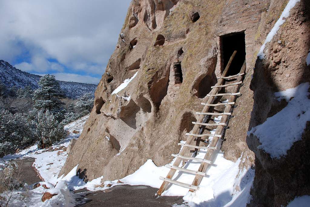
Photo: NPS
Dripping Springs Trail (Desert Peaks National Monument near Las Cruces)
Mileage: 3 miles
Difficulty: Easy
A relatively easy and highly accessible trail leading to the historic ruins of the Van Patten Mountain Camp (a 19th-century resort) and a charming, usually flowing waterfall area within a riparian oasis.
It’s nestled in a beautiful desert mountain setting, offering really interesting views into the area’s past and ecology.
Dog Canyon Trail (Oliver Lee Memorial State Park near Alamogordo)
Mileage: 11 miles
Difficulty: Strenuous
The Dog Canyon Trail is a challenging and dramatic hike that climbs steeply from the Chihuahuan Desert floor up through multiple ecological zones into the rugged Sacramento Mountains. As you climb, you’ll be treated to increasingly expansive views of the vast Tularosa Basin and White Sands National Park below — a worthy reward for a hard day of hiking!
Northern New Mexico
Northern New Mexico is a hiker’s paradise, boasting the towering peaks of the Sangre de Cristo and Jemez Mountains.
Wheeler Peak Trail (near Taos)
Mileage: 8 miles
Difficulty: Strenuous (primarily due to altitude)
The 13,000-foot summit of Wheeler Peak is the highest point in New Mexico, and you can access it on foot. While not a technical climb, the high altitude and exposed alpine environment make this summit a significant challenge. The reward is expansive panoramic views of the Sangre de Cristo Mountains and the surrounding wilderness from the summit fire lookout.
Trampas Lakes Trail (Pecos Wilderness)
Mileage: 12 miles
Difficulty: Strenuous
This is a longer, more challenging hike deep into the stunning alpine lakes basin of the Sangre de Cristo Mountains. The trail is renowned for its numerous clear, high-elevation lakes nestled in glacial cirques (such as Trampas Lakes and Pecos Baldy Lake), vibrant wildflowers, and pristine wilderness scenery.
READ NEXT –
Best Day Hikes in the Mountain West: Colorado
Across the Centennial State, hikers can discover a vast spectrum of landscapes, including towering peaks, deep canyons, expansive forests, and high-altitude deserts. The sheer variety ensures opportunities for all skill levels, with seasons dictating accessibility and necessary gear.
I may be biased, but I truly believe Colorado includes some of the best day hikes in the entire United States, let alone the Mountain West.
Rocky Mountain National Park
Can’t talk about the best day hikes in the Mountain West without talking about RMNP. This iconic park provides a quintessential Colorado mountain hiking experience. Visitors can explore a world of subalpine and alpine ecosystems characterized by stunning vistas, abundant wildlife, and dramatic changes in elevation.
Emerald Lake Trail
Mileage: 3.2 miles
Difficulty: Moderate
This highly popular and incredibly scenic hike visits three distinct and beautiful alpine lakes in succession: the lily pad-dotted Nymph Lake, the serene Dream Lake with its iconic view of Hallett Peak, and the stunning, stark Emerald Lake, all set against a dramatic mountain backdrop.

Photo: @k80.trail on Instagram
Sky Pond via Glacier Gorge Trail
Mileage: 9 miles
Difficulty: Strenuous
A challenging but incredibly rewarding hike that passes several captivating features, including Alberta Falls, the serene Loch Vale, and the dramatic Timberline Falls (requiring a scramble up a waterfall), before reaching the breathtaking alpine cirque of Sky Pond, surrounded by towering summits like Taylor Peak.
Alberta Falls Trail
Mileage: 1.7 miles
Difficulty: Easy
A relatively short and very popular hike leading to a picturesque 30-foot cascading waterfall, Alberta Falls, surrounded by pine forests. Its accessibility from multiple trailheads makes it a favorite for families and those seeking a quick yet scenic outing along a lively stream.
Front Range (Near Denver/Boulder/Colorado Springs)
Extending from the foothills up into the peaks, the Front Range offers a convenient and popular hiking destination for many residents and visitors. Its proximity to major cities means easy access to trails with varied terrain, showcasing a mix of pine forests, open meadows, and panoramic views of the plains to the east.
Manitou Incline (Manitou Springs)
Mileage: 1 mile (up the Incline) and 3.3 miles (down the Barr Trail)
Difficulty: Strenuous
A unique and extremely challenging climb straight up the side of a mountain via 2,744 repurposed old railroad ties, offering an intense test of endurance with a gain of over 2,000 feet in just one mile. It provides rewarding panoramic views and is often combined with a descent via the more gradual Barr Trail.
The Royal Arch Trail (Boulder)
Mileage: 3.4 miles
Difficulty: Moderate
A popular hike in Boulder’s scenic Chautauqua area that leads to a distinctive natural stone arch formation, the Royal Arch, carved into the sandstone. It provides great close-up views of the iconic Flatirons and expansive vistas of the city of Boulder below.
Trading Post Trail (Red Rocks Park)
Mileage: 1.4 miles
Difficulty: Easy
A scenic loop trail winding directly through the iconic, towering red sandstone formations of Red Rocks Park, including the famous Ship Rock and Creation Rock. It offers beautiful close-up views of unique rock structures and the world-renowned Red Rocks Amphitheater.
Garden of the Gods (Colorado Springs)
Mileage: 1.2 miles (but varies based on trails chosen)
Difficulty: Easy
A free public park featuring striking, ancient red sandstone formations that dramatically jut out of the earth, including famous formations like the Kissing Camels and Balanced Rock. It offers numerous short, easy paved and unpaved trails that wind among these towering natural sculptures.
Central Colorado
This region is yet another hiker’s paradise, often characterized by its high peaks and deep valleys. It boasts a rugged beauty, with numerous opportunities for challenging climbs to elevations well above treeline, as well as more moderate hikes through aspen groves and along waterways.
Grays Peak & Torreys Peak
Mileage: 8 miles
Difficulty: Strenuous
Often hiked together, these are two of the most accessible 14ers from the Denver area, offering a true taste of high-altitude summiting with challenging but generally non-technical trails that often wind past mountain goats along the way! The traverse between the two peaks involves a phenomenal ridge walk with views on both sides.

Photo: @k80.trail on Instagram
Mount Bierstadt
Mileage: 7 miles
Difficulty: Strenuous
Another very accessible 14er from the Front Range, Mount Bierstadt is known for being a good “starter” 14er. The trail offers a straightforward ascent up Guanella Pass to a significant, broad summit, providing expansive views of the Front Range and surrounding peaks.
As with all high-altitude hikes (really, all hikes in general!), keep an eye on how you’re feeling and keep yourself open to the idea of turning back without reaching the summit.

Photo: @k80.trail on Instagram
Quandary Peak
Mileage: 7 miles
Difficulty: Strenuous
A popular 14er near Breckenridge, Quandary Peak is known for its distinctive, pyramid-shaped summit and a well-marked trail that makes for a challenging but rewarding day hike. It’s often frequented by mountain goats and provides impressive views of the Tenmile Range.

Photo: @k80.trail on Instagram
Southwestern Colorado
Defined by its unique geological features and cultural history, southwestern Colorado presents a distinct hiking landscape. Here, adventurers can explore red rock canyons, ancient Puebloan dwelling sites, and expansive mesas, offering a blend of natural beauty and history.
Ice Lake Basin
Mileage: 8 miles
Difficulty: Strenuous
A stunning but challenging hike leading to a basin filled with strikingly vivid, intensely turquoise alpine lakes, notably Ice Lake and Island Lake, all surrounded by dramatic 13,000-foot peaks. The area is particularly famous for its spectacular displays of wildflowers in summer.
Blue Lakes Trail (Mt. Sneffels Wilderness)
Mileage: 9 miles (to the upper lakes)
Difficulty: Strenuous
This trail climbs to a series of incredibly beautiful alpine lakes (Lower, Middle, and Upper Blue Lakes) known for their brilliant sapphire hues, nestled directly beneath the imposing, jagged north face of Mount Sneffels. It offers unparalleled scenery and challenging climbs to reach the higher lakes.
Maroon Lake Scenic Trail / Crater Lake Trail (Maroon Bells)
Mileage: 1 mile for the Maroon Lake Loop and 3.6 miles round trip to Crater Lake
Difficulty: Easy-Moderate
This area offers iconic, postcard-perfect views of the Maroon Bells (“the Deadly Bells”) reflecting in Maroon Lake, one of Colorado’s most photographed spots. The trail to Crater Lake provides a closer, less crowded look at the base of these distinctive red-striped peaks. (Note: Access is often restricted, requiring reservations during peak season).
Western Slope
Characterized by its diverse terrain, the Western Slope encompasses a range of environments from river valleys to arid desert and giant mountain ranges. Hiking here can involve exploring fruit orchards, vast national forests, and dramatic canyonlands carved by powerful rivers.
Rattlesnake Canyon Arches Trail (near Fruita)
Mileage: 5 miles
Difficulty: Moderate
This unique desert hike features the second-highest concentration of natural arches in the world after Utah’s Arches National Park, including the impressive Rattlesnake Arch and Centennial Arch. It offers a rugged and memorable experience among these stunning, lesser-known rock formations.
Best Day Hikes in the Mountain West: Wyoming
This state offers a truly wild hiking experience, characterized by vast open spaces, dramatic mountain ranges, and abundant wildlife. From high-alpine adventures to sagebrush plains, Wyoming’s trails often lead to remote and pristine environments, demanding self-reliance but compensating with unbelievable views.
Grand Teton National Park
Dominated by the soaring, jagged peaks of the Teton Range, this park offers some of the most visually stunning alpine hiking in the United States. Trails lead through glacial valleys, past turquoise lakes, and up to high mountain passes, all framed by the majestic granite spires.
Cascade Canyon Trail
Mileage: 9.4 miles from the Jenny Lake West Boat Dock
Difficulty: Moderate
A stunning hike that leads deep into a glacially carved canyon with dramatic, up-close views of towering peaks like the Grand Teton, Mount Owen, and Teewinot Mountain. The trail is known for its consistent and spectacular scenery, often featuring moose sightings. A boat shuttle across Jenny Lake can significantly shorten the approach.
Hidden Falls & Inspiration Point
Mileage: 1-2 miles from the Jenny Lake West Boat Dock
Difficulty: Easy
Often done in conjunction with the Jenny Lake Trail or a boat shuttle, this popular route leads to the beautiful Hidden Falls, a powerful cascading waterfall, and then climbs to Inspiration Point, offering panoramic views of Jenny Lake and the vast Jackson Hole valley.
Jenny Lake Loop Trail
Mileage: 7.5 miles
Difficulty: Moderate
A picturesque loop trail circling Jenny Lake, providing stunning views of the Teton Range reflecting in its clear waters and numerous vantage points of Teewinot Mountain and Mount St. John. It can be combined with other popular hikes or shortened using the scenic boat shuttle.
Taggart Lake & Bradley Lake Loop
Mileage: 5.5 miles (or 3.3 miles for Taggart Lake only)
Difficulty: Moderate
A popular loop hike that visits two beautiful lakes (Taggart Lake and the more secluded Bradley Lake) nestled at the base of the majestic Tetons. It offers lovely mountain reflections, relatively moderate terrain, and is known for its classic Teton views.
Yellowstone National Park
As the world’s first national park, Yellowstone provides a unique hiking opportunity amidst its geothermal wonders. Hikers can explore a landscape dotted with geysers, hot springs, and vibrant pools, alongside dense forests, sprawling meadows, and the chance to observe iconic wildlife in their natural habitat.
Mystic Falls Trail
Mileage: 3.9 miles
Difficulty: Moderate
This trail travels through a forested area along the Little Firehole River to the impressive 70-foot tiered Mystic Falls. An optional, more strenuous loop climbs above the falls, providing a spectacular overlook of the vibrant colors and steaming features of the Upper Geyser Basin.
Grand Prismatic Spring Overlook Trail
Mileage: 1.2 miles
Difficulty: Easy
A relatively short and easy hike that culminates in a spectacular elevated view of the vibrant, iridescent blues, greens, yellows, and oranges of Grand Prismatic Spring, one of Yellowstone’s largest and most famous thermal features, offering a unique perspective of its scale and color.
Mount Washburn Trail
Mileage: 6 miles
Difficulty: Moderate
A popular mountain summit hike offering panoramic 360-degree views of Yellowstone National Park from a historic fire lookout tower. The trail is known for its beautiful summer wildflowers and frequent sightings of bighorn sheep near the summit.
Fairy Falls Trail (including Grand Prismatic Overlook)
Mileage: 6 miles
Difficulty: Moderate
This trail leads to the tall and beautiful Fairy Falls, a graceful 200-foot waterfall. The popular spur trail providing an incredible elevated view of Grand Prismatic Spring is often combined with this hike, offering a diverse experience of both a thermal feature and a classic waterfall.
Wind River Range
For serious backpackers and mountaineers, the Wind River Range is a premier destination — but it also offers some of the best day hikes in the Mountain West.
This remote and wild range boasts numerous peaks exceeding 13,000 feet, extensive glaciers, and thousands of pristine alpine lakes. Hiking here often involves multi-day trips into a truly undeveloped wilderness, requiring strong navigational skills and preparedness.
Cirque of the Towers Section (To Lonesome Lake)
Mileage: 10 miles
Difficulty: Strenuous
While the full Cirque of the Towers is a challenging multi-day backpacking trip, day hike portions from the Big Sandy Trailhead offer stunning, iconic views of the dramatic, jagged granite peaks (e.g., Pingora, Warbonnet, Wolf’s Head) surrounding the serene Lonesome Lake and the awe-inspiring Cirque itself. Reaching Lonesome Lake and returning makes for a challenging day hike into truly spectacular alpine scenery.

Photo: @k80.trail on Instagram
Green River Lakes Loop
Mileage: 7.7 miles
Difficulty: Moderate
A scenic loop hike around the pristine lower and upper Green River Lakes, offering impressive, iconic views of the northern Wind River Range peaks, particularly the majestic Squaretop Mountain reflecting in the lake’s waters. The trail provides classic Wyoming wilderness scenery.

Photo: @k80.trail on Instagram
Other Wyoming Areas
Beyond its famous national parks, Wyoming offers a wealth of diverse hiking experiences. This includes exploring the Bighorn Mountains with their expansive forests and rocky peaks, trekking through the stark beauty of the Red Desert, or discovering trails in the numerous national forests and state lands.
Tower Trail (Devils Tower National Monument)
Mileage: 1.3 miles
Difficulty: Easy
A paved loop trail that circles the base of the iconic Devils Tower, a striking igneous intrusion with unique columnar jointing (if you’ve visited or seen pictures of the Giant’s Causeway in Ireland, this is the same type of rock formation). It offers intimate, close-up perspectives and constant views of this revered geological formation from all angles.
Medicine Bow Peak Trail (Medicine Bow-Routt National Forest)
Mileage: 8 miles
Difficulty: Strenuous
A challenging hike to the highest point in the beautiful Snowy Range, offering rugged alpine scenery, numerous small lakes (like Brown’s Lake), and panoramic views from the exposed, rocky summit of Medicine Bow Peak.

Photo: @k80.trail on Instagram
Best Day Hikes in the Mountain West: Idaho
Idaho has a vast and often-untamed wilderness. With more designated wilderness than any other state outside of Alaska, Idaho’s landscapes include mountains, alpine lakes, deep canyons, and forests.
From easy day hikes to multi-day backpacking expeditions, the Gem State provides opportunities for all skill levels to experience genuine solitude and stunning natural beauty.
Central Idaho (Sawtooths & Sun Valley Area)
This region is home to some of Idaho’s most iconic and remote wilderness areas, including the vast Frank Church-River of No Return Wilderness. Hikers here find themselves in towering peaks like the Sawtooth Mountains, countless sparkling lakes, and expansive forests, often encountering wildlife and dramatic elevation changes.
Sawtooth Lake Trail
Mileage: 11 miles
Difficulty: Moderate – Strenuous
One of the most iconic and popular hikes in the stunning Sawtooth Mountains, leading to Sawtooth Lake, a pristine alpine lake surrounded by dramatic, jagged “sawtooth” peaks like Mount Cramer. The trail also passes by the beautiful Alpine Lake and offers classic wilderness views.
Baron Lakes Trail
Mileage: 17 miles
Difficulty: Strenuous
A challenging hike deep in the Sawtooths that rewards hikers with a series of incredibly beautiful alpine lakes (Lower, Middle, and Upper Baron Lakes) nestled in a dramatic basin beneath towering granite walls. Access can be shortened by a scenic boat shuttle across Redfish Lake.

Photo: Seek writ awe there
Bench Lakes Trails
Mileage: 10 miles
Difficulty: Strenuous
This trail system offers access to a chain of five beautiful lakes (Bench Lakes) at the base of the dramatic Sawtooth Mountains, providing stunning reflections of the peaks. You can hike to just the first lake for a shorter trip or continue to the upper lakes for a longer, more challenging day.
Pioneer Cabin Trail (Sun Valley Area)
Mileage: 9 miles
Difficulty: Strenuous
A challenging and very popular climb to a historic stone cabin (Pioneer Cabin), built in the 1930s, perched high on a ridge with incredible panoramic views of the Pioneer Mountains. While hard, this is a highly rewarding hike near Sun Valley.
Northern Idaho
Characterized by its lush landscapes and abundant water, Northern Idaho provides a different kind of hiking experience. Here, you’ll find deep forests, pristine lakes like Coeur d’Alene and Pend Oreille, and scenic river valleys. Trails range from easy strolls through old-growth cedars to more challenging ascents with views of the “panhandle.”
Tubbs Hill Trails (Coeur d’Alene)
Mileage: 2.4 miles
Difficulty: Easy
Located on a scenic peninsula jutting into Lake Coeur d’Alene, this popular urban hike offers multiple interconnected trails with beautiful views of the lake, surrounding mountains, and various small beaches, perfect for a refreshing walk or swim.
Scotchman Peak Trail
Mileage: 8 miles
Difficulty: Strenuous
A strenuous but exceptionally rewarding hike to the summit of Scotchman Peak, the highest point in Bonner County. It offers expansive 360-degree views of Lake Pend Oreille and the Cabinet Mountains, and is famous for potential mountain goat sightings near the summit.
Mineral Ridge National Recreation Trail
Mileage: 3.3 miles
Difficulty: Moderate
A well-maintained loop trail offering scenic views of Lake Coeur d’Alene and featuring numerous interpretive signs that explain the area’s history, ecology, and unique geological formations, making for an educational and pleasant hike.
Pulaski Tunnel Trail (Wallace)
Mileage: 4 miles
Difficulty: Moderate
A historic trail following the escape route of firefighters during the devastating Great Fire of 1910, leading to an overlook of the Pulaski Tunnel, built as a refuge. It offers a mix of compelling history, informational plaques, and a pleasant forest hike along Placer Creek.
Southern Idaho
This area, often encompassing the Boise Front, offers easily accessible trails from urban centers. Hikers can enjoy a mix of rolling foothills, open meadows, and pine forests, with trails providing excellent views of the city and surrounding natural areas.
Table Rock (Boise)
Mileage: 3.7 miles
Difficulty: Moderate
A very popular hike just outside of downtown Boise that climbs to a prominent sandstone mesa capped with a large cross (built in 1956). It offers panoramic views of the city lights and the vast Treasure Valley, and is especially popular for sunsets.
Craters of the Moon National Monument & Preserve (Various Trails)
Mileage: Varies (from short loops like the Inferno Cone Trail, ~0.4 miles, to longer options)
Difficulty: Easy – Moderate
Explore a unique, otherworldly landscape of vast black lava flows, cinder cones (like Inferno Cone), and fascinating lava caves (like Indian Tunnel). Offers several short interpretive trails that provide insights into the area’s volcanic geology and hardy pioneer life.
Balanced Rock Trail (Bruneau Dunes State Park)
Mileage: Balanced Rock Trail is very short; hiking the dunes is variable mileage
Difficulty: Easy (Balanced Rock) to Strenuous (hiking on sand dunes)
While the towering, shifting sand dunes (North America’s tallest single-structure dunes) are the main draw (and are challenging to hike!), this park also features trails exploring the high desert, including a short path to the naturally balanced rock formation, precariously perched on a small pedestal.
Snake River Canyon Rim Trail
Mileage: Varies depending on how far you go (part of a longer trail system)
Difficulty: Easy
This trail takes you over a paved pathway along the dramatic rim of the Snake River Canyon, offering spectacular views of the canyon’s basalt walls, the iconic Perrine Bridge (a popular BASE jumping spot), and the powerful Shoshone Falls (often called the “Niagara of the West”). Excellent for a scenic walk or bike ride.
Hells Canyon National Recreation Area (Idaho side)
Mileage: Varies greatly depending on the section hiked
Difficulty: Moderate – Strenuous
This area offers glimpses into the deepest canyon in North America. While the full trail is very long, sections can be hiked as challenging day trips from various access points on the Idaho side, providing dramatic canyon and river views, often with glimpses of abundant wildlife like bighorn sheep.
Best Day Hikes in the Mountain West: Montana
Known as “Big Sky Country,” Montana offers a grand and diverse hiking experience. From the peaks of its western ranges to the plains and badlands of the east, hikers can explore a wide variety of environments, often with opportunities for wildlife viewing and a sense of wilderness.
Glacier National Park
Glacier National Park is renowned for its dramatic, glaciated peaks, crystal-clear turquoise lakes, and abundant wildlife. Trails range from easy strolls through cedar forests to strenuous climbs over high mountain passes, offering unparalleled scenery and a true immersion in an alpine wonderland.
This park continuously finds itself at the top of lists of America’s most beautiful national parks for a reason.
Grinnell Glacier Trail
Mileage: 10.6 miles
Difficulty: Strenuous
A strenuous but exceptionally rewarding hike that leads to the base of the stunning Grinnell Glacier, surrounded by turquoise glacial meltwater lakes (Grinnell Lake, Josephine Lake, Swiftcurrent Lake) and towering peaks. It offers unparalleled views of the actively receding glacier and surrounding alpine scenery. It can be shortened by a boat shuttle.
Hidden Lake Overlook Trail
Mileage: 2.8 miles
Difficulty: Easy
A highly popular, relatively short hike from Logan Pass that features a picturesque boardwalk through vibrant alpine meadows dotted with wildflowers and mountain goats. It culminates at a breathtaking overlook with panoramic views of Hidden Lake and the majestic surrounding mountains.
Avalanche Lake Trail
Mileage: 5.7 miles
Difficulty: Moderate
A classic Glacier hike that winds through a lush cedar and hemlock old-growth forest along the vivid blue-green Avalanche Creek, known for its unique polished slot canyon. It leads to the beautiful Avalanche Lake, nestled in a dramatic cirque with numerous waterfalls cascading down the surrounding cliffs.
Highline Trail (to Haystack Butte or Granite Park Chalet)
Mileage: 7 miles (to Haystack Butte) or 15 miles (to Granite Park Chalet and back)
Difficulty: Moderate – Strenuous
An iconic trail offering dramatic exposure and incredible views along the “Garden Wall,” a prominent ridge on the Continental Divide, often frequented by mountain goats. Day hike options include hiking to Haystack Butte and returning or hiking further to Granite Park Chalet, providing a true high-alpine experience.

Photo: @k80.trail on Instagram
Southwestern Montana (Near Bozeman/Big Sky)
Southwestern Montana is defined by its mountain ranges and a mix of well-known and secluded trails. This region contains portions of the Rocky Mountains including the Gallatin, Madison, and Tobacco Root ranges, providing a stunning backdrop for any hike.
The area offers everything from gentle riverside strolls to strenuous climbs that reward you with expansive views and a deep sense of Montana’s “Big Sky” wilderness.
Beehive Basin Trail
Mileage: 6.6 miles
Difficulty: Moderate
A popular hike near Big Sky that leads to a pristine alpine lake tucked away in a stunning glacial cirque, resembling a natural amphitheater, with dramatic mountain scenery surrounding the clear waters. It’s known for its abundant wildflowers in summer.
Sacagawea Peak Trail
Mileage: 4.3 miles
Difficulty: Strenuous
A challenging hike to the highest point in the Bridger Mountains, offering panoramic 360-degree views of the Gallatin Valley, surrounding ranges, and a distinctive “M” landmark below (from the nearby Bozeman Trail) from its exposed summit.
Palisade Falls Trail
Mileage: 1.2 miles
Difficulty: Easy
A short, paved, and accessible trail leading to a beautiful 80-foot waterfall (Palisade Falls) cascading over ancient volcanic basalt cliffs in the scenic Hyalite Canyon area south of Bozeman, perfect for a quick, family-friendly outing.
Western Montana (Near Missoula/Bitterroot Valley)
This region is dominated by several prominent mountain ranges like the Bitterroots, Missions, and Cabinets. Hikers can discover dense forests, deep valleys, high alpine lakes, and impressive waterfalls, often with opportunities for multi-day backcountry trips into expansive wilderness areas.
Mount Sentinel “M” Trail (Missoula)
Mileage: 1.5 miles
Difficulty: Moderate (to the M) and Strenuous (to the summit)
A very popular, steep hike directly in Missoula that climbs to the iconic concrete “M” (for the University of Montana) overlooking the city and the Missoula Valley. You can continue to the true summit for even broader panoramic views and a strenuous workout.
Stuart Peak Trail (Rattlesnake National Recreation Area)
Mileage: 11 miles
Difficulty: Strenuous
A longer, more challenging hike north of Missoula that climbs through forested areas to an open summit with excellent views of the surrounding Rattlesnake Mountains, Mission Mountains, and the distant Flathead Lake. It offers a true wilderness feel close to the city.
Other Montana Areas
Beyond its famous western mountains and national parks, Montana conceals some of the best day hikes in the Mountain West in its lesser-known but equally interesting regions. These include the Beartooth Mountains with their high plateaus and alpine lakes, the vast and often remote prairies, and the numerous national forests and wilderness study areas scattered across the state, each offering its own unique appeal.
Pictograph Cave State Park Trails (Billings)
Mileage: Varies (short loops, less than 1 mile)
Difficulty: Easy
This area offers short loop trails that lead to caves containing ancient pictographs (rock paintings) dating back thousands of years, providing a fascinating glimpse into the area’s human history and offering views of the surrounding landscape.
Apikuni Falls Trail (Many Glacier area of Glacier NP — accessible from east side)
Mileage: 2 miles
Difficulty: Moderate
A relatively short and steep hike leading to a beautiful tiered waterfall, Apikuni Falls, cascading down a cliff face. It offers immediate and impressive views of the Many Glacier Valley and Altyn Peak with a relatively short effort.
Hopefully it goes without saying, but this is by no means a comprehensive list of the best day hikes in the Mountain West. It’s one of the richest hiking regions in the US, with nearly unlimited potential for routes of any length and difficulty.
Happy Hiking!
Featured image: Photo by Roy Luck. Graphic design by Chris Helm.

")
