
My Hiking Season Kick-Off
I got to Hayden Pass TH the night before my shuttle was scheduled. I’ve been camping out of Potassium, my Honda Element, for a month now with great success and was going to miss sleeping in the build out. But nothing beats laying the ol’ noggin down in a tent, resting on a stuff sack of lumpy clothes and adventure.
The shuttle was fantastic, shout-out to CJ who runs MTXutah! I met several other hikers, two starting with me at Leidy, “Cinelli” & “Avid”, and one who had just finished the Highline, “Dumbledore.” This worked out because I got the nervous excitement from two, and experienced stories from the others. The hours before beginning the Uinta Highline flew by with chatter in the van, and panic pitstops for the last use of gas station bathrooms and refrigerated beverages.
U-IN-TA Hiking? (Only dad-joke of the blog, promise.)
The Uinta Mountains are an East-West range to the east of Salt Lake City, Utah. The High Uinta Wilderness is the largest wilderness designation in Utah, and yet it’s relatively un-talked of. To see the most of this incredible landscape is to hike the Highline trail stretching east from McKee Draw, 101 miles west to Hayden Pass. A popular starting option is to nix the first 21 miles of weird wet field hiking and begin at Leidy Peak for an 80 mile hike. This is the option I took.
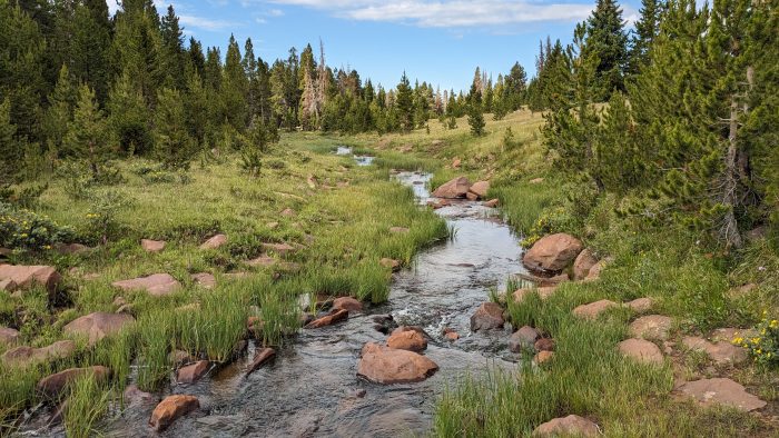
The Uinta Highline is not blazed in the common sense and does not have a FarOut package as of 2025, so I carried a set of paper maps I had customized on CalTopo and a gpx on my Garmin inreach. There are large historic cairns and signage at major trailheads and intersections but for the most part it helps to have some route beta ahead of time. There is a trail to follow for the most part, or at least a trail trace. Everyone finds themselves covering open ground at some point and needs to be comfortable with navigating by simple direction or visuals on the landscape. So much of this trail is high alpine terrain and exposure above treeline. Daily thunderstorms were a common occurrence.
I planned on making small side trips to summit peaks like Utah’s highest: Kings Peak. Most camping is done lower down near alpine lakes, of which there are numerous. There are 8 passes along the 80 miles of trail, the lowest being 11,300′ and the tallest at 12,800′. Since the passes are the highlights of the hiking day, I figured I would organize my overview of the trail by pass instead of days or meals…
Beginning: Leidy Peak & Gabbro Pass (11,700′) 7 Miles
The shuttle arrived promptly at 12:30pm where CJ wished us well and drove off, leaving us to our fate. Beginning at Leidy Peak TH was a satisfactory idea but it did start at 10,900′, and it’s all up from there darlin’! My pack, weight unknown, felt heavy but road on my hips in a nice familiar way. I burdened myself with 8 days worth of food, just in case I overestimated my fitness and needed extra days to crawl across some high alpine, or had some rowdy thunderstorms to make a skittish thing of me. As I wound south around Leidy Peak, a “Bollie” as these bald piles of rocks are called, I let the anxiousness fall away and smiled at the world.
“Avid” & “Cinelli” had taken the northern path around Leidy Peak which shaved off a mile, but I knew I would be able to see them ahead of me and take some cues as to which routes to take. We were already on exposed open meadow within the first 5 miles, and there was no trail to follow. I simply picked a direction based on the cairns standing lonely against the horizon and hiked from one to the other. I caught up to “Cinelli” and together we were up and over Gabbro Pass by 3pm! I didn’t feel the altitude at all and the weather stayed cool and overcast.
We camped early at Deadman Lake not wanting to push too hard on the first day. I set up my tent on some open ground with a great view of the lake and the unnamed pass saved for the next morning. My tent already felt like home. I know I may be one of the lucky ones, but I sleep like a baby on trail – better than a baby. I feel like I may have been a gas station taquito in a past life on account of my consistent turning to find warmth, but I always wake up refreshed and have been known to sleep for 9 to 12 hours given the chance.
North Pole Pass (12,200′) 15 Miles
My first full day was a dream and a doozy. The forested morning walk to Chepeta Lake was lovely if not a little moist. There were miles of wet dew grass and boggy fields that get the trail runners saturated. Cinelli & I got unexpected trail magic from a family of campers who filled cups of orange juice and pushed blueberry muffins on us. Even carrying a pack heavy with calories, I couldn’t say no! It was 11:30am when we walked away from Chepeta Lake and the day turned gloomy. A thunderstorm, cold with constant rain fell for two hours. I hiked in full raingear trying to stay warm, and hoping that by the time I came to the exposed climb of North Pole Pass, the storm would be over. Unfortunately the rest of the day was touch-and-go. I curled up under a pine tree for an hour in the rain, only to hike like mad when the sun came out long enough to get a mile or two higher. I wasn’t fast enough though, as clouds over the pass grew dark again and I made a makeshift shelter with my trusty tyvek.
With three miles of exposed walking to do, I gave up waiting for blue skies and went for the pass only slightly comforted that there wasn’t lightning in the grey drizzle sky. The climb seemed unending with false pass after false pass at the horizon. It was beautiful in it’s starkness and I could kind of see why it got it’s name “North Pole.” I’m not much of a Christmas person so I got the heck through there quick. No sightings of reindeer, elves or jolly narwhales.
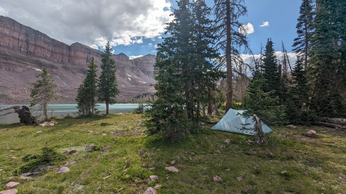
I got to Fox Lake by 6pm to set up camp. There was a cool old cabin to check out, and a cushy moss beach to set the tent on. Cinelli arrived and we were both beat from the day. Not too tired, however, to freak out when a bull moose appeared on the far side of the lake and proceeded to swim across right in front of us!
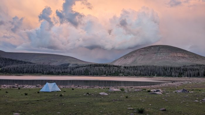
Camp at Fox Lake
Anderson Pass (12,800′) & Kings Peak (13,528′), Tungsten Pass (11,400′) 11 Miles & 9 Miles
Day 3 was a timid maintenance mileage day. Cinelli and I decided to do the 11 miles of fair and forgiving trail up to the base of Anderson Pass where we could make a go early and strong. The campsite was right off a creek as close to the base of the climb as we could get. No matter how many different resources we consulted between us, Cinelli and I never could quite figure out mileage or distance between landmarks, or indeed the entire trail. Was it 80 miles? 88? How many from pass to pass? How many did we just hike? Everything told us something different. A funny characteristic of this trail that Cinelli deemed “The Uinta Asterisk.” All mileage for the day comes with the Uinta “*” attached to it, because… who knows?! Could be more, could be less!
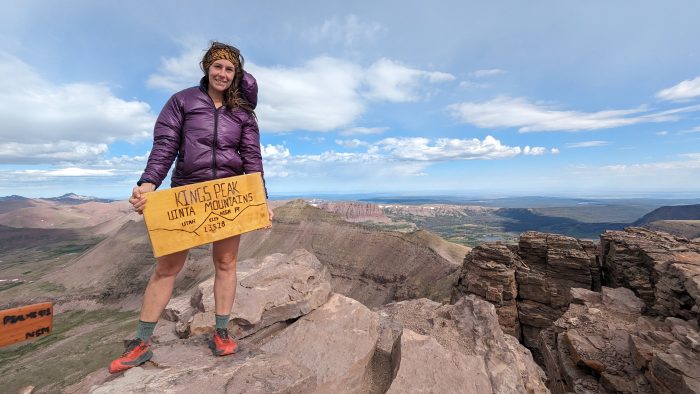
The next morning, I worked my way up Anderson Pass, the highest of the trail, and was proud to drop my pack at the top by 8am! Leaving my pack at the pass, I then began the epic Class II scramble to the top of Kings Peak. I love the movement of walking/ crawling across boulders and scree. It is exhausting to ascend 900′ in less than a mile, but I stood on top of Utah by 9am. It was cold and windy, with little flurries of snow on the air, but it was stunning. I high-tailed it down hill and caught up with Cinelli towards Tungsten Pass, which somehow doesn’t seem like a pass at all. We camped just past it at North Star Lake. We had only hiked 9 miles for the day, but had achieved two passes! The weather was touchy again, with blazing hot sun directly burning me, or cold and windy rain showers, back and forth moment to moment.
Being in camp for so long when there is so much daylight left was messing with me. I kept feeling like there were more miles I could achieve in the day, even though I was drowsy and comfortable by 4pm. I wasn’t sure how I wanted the rest of the trail to unfold until I met the “Wyoming Way.” A group of four men camped nearby on a rocky hill with a few scrub trees overlooking the lake. A friend group from Evanston, WY and Salt Lake City, UT, they were locals to the Uinta Mountains but had never hiked the whole Highline and were making the most of it! Cinelli and I met them as they came down to the lake where they began fishing as they had done in almost every lake for the last 40 miles. They hadn’t had much luck until now, but North Star Lake had some magic in it. They had lovely colorful Brook Trout practically flying out of the water into their arms! I went over to marvel at the bounty and share in the excitement. I have never been a fisherman, but the idea of having such a simple peaceful hobby to occupy your time while backpacking was intriguing. I listened to them banter and joke, but I also heard the knowledge of water, species, and fly that came like second-nature to them. They were so familiar with this landscape, and were in touch with it the way that I always long to be in any wild place. With literally handfuls of trout, we all went back to their camp where Cinelli and I were treated to fresh fish over a campfire. We laughed and ate together and I enjoyed a social trail experience I didn’t know was possible on the Uinta Highline. We all went out there expecting to be in complete solitude for a week, and instead I was making trail friends with the same gusto as I had done on the PCT!
The “Wyoming Way” group as I call them, were challenging themselves with big mileage goals that more aligned with my own. I determined to not be afraid of multiple passes in a day, and decided I would make it to Dead Horse Lake by next camp.
Porcupine Pass (12,200′) & Red Knob Pass (12,000′) 16 Miles
I said farewell to Cinelli as he was more content to keep the same pace and make the trail really last a full 7 days. I took off with my more ambitious pace up Porcupine Pass feeling recovered and ready for some miles. While the steep hikes up were still difficult, my pack was lighter every day and I was sucking air a little less with every climb. The wind was whipping and I kept my rain gear on until I got to the bottom where I hiked alone through a heavenly valley. Today the weather was superb, and it was blue skies and white puffy clouds over long stretches of meadow and pine forests. Babbling brooks bubbled every couple miles where I could scoop up a bottle and chug the cool water as I walked. There were sheep herds here, hundreds grazing across the open hills, allowably grandfathered into the High Uinta Wilderness designation in 1997. Lambs perched atop boulders, and the bleating was as common as birdsong. I liked watching their little ears flop up and down as they ran away from me when I passed through.
I got off trail around some deadfall after Lambert Meadow and ended up higher than the supposed trail trace. I carefully navigated a boulder field and scared up some mule deer and elk while I crossed country trying to find the path again. It took me about 45 minutes to relocate the nice trodden dirt ribbon that set me right. I have bushwhacked plenty at home in Arkansas, and feel comfortable off-trail for the most part. It is easier to take a heading and stick to it in the Uintas’ because, unlike Arkansas, you can see where you’re going through the trees and also see major landmarks on the horizon above treeline.
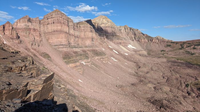
I tackled Red Knob Pass which put up a fight, but I was ecstatic at the top. It was the most jaw-dropping scene on either side, to the East from which I came, and to the West where I was bound. On the way down I walked a narrow saddle between Red Knob North & Pass Peaks, treacherous in bad weather, but stunning on a perfect day like this! I hiked quickly the last few miles, high on the thought that I had accomplished two passes in the same day with higher mileage, good weather, and plenty of daylight. I hiked through thick woods of large trees like only the north slope of a mountain can grow, and everywhere was carpeted with wildflowers. Even as I misinterpreted a trail sign and went the wrong way, my good mood could not be brought down. I realized I was going the wrong direction of Dead Horse Lake about a quarter of a mile in and turned around to back-track when I saw an odd sight, a porcupine desperately trying to make a getaway! Well, too bad porcupine, you’re too much of a funny creature to hide, and I was over the moon to see you.
Just to clear up any confusion: porcupines raise their scary pointy backend when threatened, they cannot launch their quills out at an attacker like a Korean Hwacha. That sounds more like a pokemon (which are not real.) If porcupines could throw their quills like a spear, I promise humans would not be ruling the world right now.
When I finally reached Dead Horse Lake, I was convinced it was the most beautiful campsite I had ever had the privilege to lay my head. The lake was a sparkling clear teal with walls of rock almost directly rising from it’s southern shore to Dead Horse Peaks. Pleasant woods on the north shore with ample campsites and fire rings where I picked a spot. “Wyoming Way” boys showed up not long after myself with faces expressing awe of the surroundings that matched my own. Fishing must have a rejuvenating power over a tired body, because those guys were saying how exhausted they were and baiting their fishing rods at the same time within one hot minute of arriving. It was another sweet night of eating our weight from the food bag around a fire. We all had ideas of finishing trail the next day. One last long day.
Ending: Dead Horse Pass (11,600′) & Rocky Sea Pass (11,300′) 22 Miles
Now, every person who has thru-hiked a trail understands the rampant fear-mongering that exists. Ever since I began researching the Uinta Highline, I had heard how steep, chossy, exposed, and dangerous Dead Horse Pass was. It’s where they recover bodies lost years ago. People made it seem like hiking the whole Highline trail was out of the question if there was any snow still on Dead Horse Pass… I began morning with my heart in my throat. It looked intimidating from our camp at the lake, like a steep wall with no switchbacks or ribbon of trail to be seen. I thought this was the crux of the trail. If failure was to come, it would be here. As I started up, I wondered, if I died on this would it be renamed Dead Whistles Pass?
Y’all, I am not kidding when I say that I was on top of this pass in 30 minutes. Steep? Sure. Loose rocky stuff? Yeah. But the CRUX of the trail?! Hell no. It was fun. It was short. I’d rather go up that a hundred times over than some of the other passes. When I was sitting triumphant at the top, I saw “Wyoming Way” beginning the ascent. I timed them just as I had myself and I’ll be damned if they didn’t pop up at the top in exactly 30 minutes! Dead Horse Pass was confusingly underwhelming to us, but since we made it out I guess we are stronger and more graceful than a horse. Suck it horses.
My last day on trail started out smooth, but isn’t that always like a trail to knock you down a few pegs when you’re on your high dead horse… There was a stretch of the Highline around Rock Creek which had burned several years ago and is rumored that the trail is exceptionally hard to follow with deadfall obstacles that cause a slow mile-an-hour pace. A solution some presented was to take alternate trails to the north, either Jack & Jill, or Head of Rock Creek, and have an easier time even with added mileage. I had decided to do this alternate, but too soon into my day did I come across a trail intersection with a sign pointing south to “Rock Creek.” I should have taken more time to think through the circumstances, but I was afraid of missing the alternate and finding myself in the nightmare Highline section I hoped to avoid. So I followed the wrong Rock Creek trail south about half a mile before I really used my brain. I turned around and backtracked, but then made the decision to bushwhack northwest to the real trail intersection I had wanted instead of going all the way back the way I had come. Again, it was kinda fun navigating across the land according to only simple directions, but it is tiring. I walked a mile and a half before finding the trail again. I found myself on the alternate before I realized I had even turned north.
This began an afternoon of torturous bushwhacking, most of it not on purpose, because of both the rugged burned condition of the area, but also my low patience in understanding trail intersections. (We all have our faults and I have realized this one is mine.) I am so eager to make the correct turns that I will selfishly assume each sign is there for my specific trip and I find my own courses in each. I made wrong turns, lost trails, bushwhacked my soul out for hours, always up, up, up steep terrain. The alternate Jack & Jill trail conditions didn’t seem to be much better than the Highline, but with choices made all I could do was keep pushing forward. I leaped around “Wyoming Way” who was doing a better job at navigating than I was, but bless them, they kept stopping at lakes for fishing breaks which slowed them down and kept them within my orbit. They gave me shit for seeing all the wildlife, because I was lucky enough in my wandering to scare up a herd of at least 50 elk into stampede! (I know I haven’t showered in 7 days, but what an over-reaction…)
After a long lunch break I was ready to get through this heinous section. I power hiked to Rocky Sea Pass like my life depended on it. It was such a tough trail to follow that I was fueled by frustration and anger which made me hike hard and fast. I hit the base of Rocky Sea and I made it up to the top in 18 minutes flat. Finally I had hit my flow. I was in the zone. Whether driven by goodwill, or vexation, I will take whatever feeling that leads to my hiking flow. I get miles done. I fly. I’m an athlete! The last pass of the Uinta Highline was finished, and now it was powering through to the end where my car waited at Hayden Pass TH. I overtook “Wyoming Way” who had been steadily grinding the miles down. We saw our first pack horses on trail and wished we could let them carry us the final stretch. (Sorry horses, about what I said earlier, I take it back!)
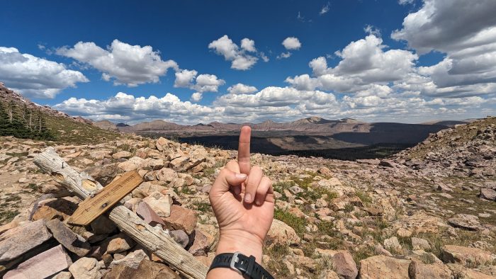
Flipping the last heinous section the bird at the top of Rocky Sea Pass.
I had been able to sustain my flow state for almost 7 miles but in the last few to Hayden Pass TH I began to slow. Everything which once was light and swift now felt heavy and labored. The weight of the days’ marvelous and messy miles were beginning to come down upon me as they inevitably do when my brain knows how close I am to finishing. My nose began to gush blood with 3 miles left. There was nothing I could do but to get to the end. My sleeve became bloody, my buff was soaked, and my face was covered even as I came to a stream and tried to clean a bit. If anyone had walked up on me then I’m sure I would have shocked them, but luckily I walked alone. The last mile was torture. I have a song that I sing called “The last mile is the longest” to the tune of Sheryl Crow’s “First Cut is the Deepest” and it helps in-between all the swearing and grumbling I do when the end never seems to come. It really is a lovely trail section, but in those last twisty, rocky, uphill steps there is nothing easier to hate. As soon as I stumbled up to the Trail Log and that beautiful pit toilet, all animosity was gone. I had finished the Uinta Highline in 5.5 days covered in blood, exhausted, and feeling so incredibly capable. I was proud of myself in a way that only thru-hiking seems to give me. And so I’m ready for the next one.
Colorado Trail is coming in August!
Saying Goodbye & Magic at the End 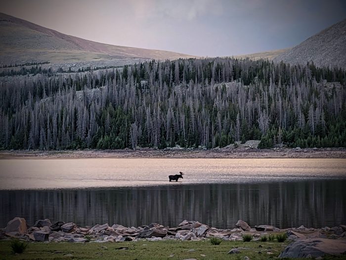
I waited for “Wyoming Way” to finish and congratulate them. They strode in right behind me and were all smiles. Some of their wives or partners had conspired to leave a cooler next to their car, and so there were frosty beverages, fresh fruit and ice immediately there to uplift us. Trail Magic is unequivocal. We said our goodbyes, but I wanted to give my thanks to them here, I hope they read this.
Wyoming Way – Thanks for sharing your fish, fires, and friendship. Your avid excitement around your small town and fishing makes me want to try fly-fishing for the first time. I’m inspired! And if anyone ever finds themselves in Evanston, WY, take a good look because there is big heart there. I am eager to visit one day.
Cinelli – You can probably guess why I chose your name, hope you approve! Thank you for being an excellent hiking partner for the first days of this trip. I hope you got the absorbing Uinta experience you wanted, and you go back to your beautiful family with a full bucket!
Dumbledore – I could see in the few short hours we spent in the shuttle together how much the Uinta Highline affected you. Thank you for sharing your more vulnerable emotions about finishing such a challenging trail. It helped me be braver in my hike! I’m very sure we will meet again down the trail.
Till next time, Whistles!


