
This morning I woke up right around 4 AM and made my morning coffee. Last night some other hikers came in super late around 10 PM. I can’t say for sure, but I can only assume that they were intentionally coming in stealthy. Birches camping is only for thru hikers. I guess it’s possible that some thru hikers arrived down at Abol last night around 6 PM. Maybe it just took them a little while to get up here. But I wasn’t sure.
Slowly but surely I got packed up and was ready to roll. After having been so sore yesterday, I was pleasantly surprised getting up this morning. Last night I was a little bit nervous about how tight I was. But once I got going today, I felt great. I made my way past the Ranger station and through the Katahdin stream campground. Then got over to the Hunt Trail, which is just the Appalachian Trail. In 2023 It took me three hours from the sign at the Hunt Trail to get to the top of Mount Katahdin. So I’m curious to see how long it takes me today.
Making my way up the Hunt Trail on the AT, heading toward Katahdin!
The first mile or so is really nice and easy terrain. There isn’t even that much elevation gain. And then the next mile is a bit more rocky and steep. But it still isn’t particularly technical. I kept my trekking poles out and they were very helpful. But as I got closer to mile three I eventually wound up putting my poles away. There just starts to be a lot of areas where you want to use your hands. The trail begins turning into more of a climb than a hike.

The first couple miles of the morning were so nice and easy.
That’s the best part of the climb up Mount Katahdin, though. It’s so fun to do a more technical rock climb. Rather than exclusively exhausting your legs, you can utilize your entire body to get you the mountain. It took a few miles to get up past tree line. And once I did, I was rewarded with some stunning views. The sky was bright and pretty clear, aside from a little bit of dark clouds off in the distance. The sky was definitely warning of some potential weather to come. But I’m quite optimistic that I’ll be able to get up and over the mountain before it does.

Some of the first views of the day. It was overcast, but still really beautiful.
The next mile and a half is probably the best part of the entire climb. At times it’s a class three scramble, meaning that it’s fairly technical, but falling would likely only result in injury and not death. There are some sections with rebar hammered into the rock face. And the only way that you could make it up the rock is because of those handholds. Everywhere else you’re just utilizing the rock to pull yourself up.

Climbing up above tree line.
Some sections of rock are far too tall, even for me. So it took a little while to lift my leg up and wiggle myself up to the next rock. I can imagine it would be a little bit harder if you were significantly shorter. I’m above average height for a girl and I still struggled at times. But it’s definitely quite manageable.

This is the spine that I climbed up once I hit tree line.
This section was slow going, but I was an absolutely no rush. I just climbed up the rocks at a regular pace and did what I could to keep my body comfortable. Shockingly though, even the odd motions that were required to climb up the rocks didn’t bother me. I actually felt significantly better this morning than I did at the end of the day yesterday. This is what I’m talking about! This is why my injury has been so incredibly confusing. Some days I feel 100% better. And the next day it’s like I’m back at 70% or 80%. And maybe not for the entire day, but for long enough to be very confused. I’m sure this is all just a part of the healing process. But it is boggling my mind.

Heading on up!

The trail weaved around these boulders, and then climbed even higher.
After climbing up the rocky spine toward the gateway, the trail levels out a lot. If you didn’t know better, you might think you were getting up towards the top of the mountain. But it’s more of a false summit. Once you get up there, the trail continues for another mile or so but it’s very gradual. For the first time all day I saw a few other hikers who were coming up to Abol Trail. A couple different trails connect around the table lands area. Then everyone seems to funnel up toward Mount Katahdin.

One of the coolest climbs along the entire AT is the trek up Mount Katahdin.
I also have been following someone’s tracks this morning. It was clear from marks in the mud and on rocks that there was someone not too far ahead of me. And when I got closer to the top, I ran into Sunflower. A hiker who I met for the first time back in Massachusetts. Then we hiked together briefly the day that I crossed into Vermont. And I saw her again a couple days ago at Shaws Hiker hostel. We chatted briefly and then I continued up to the top of the mountain, which wasn’t far now.

The gateway! Aka the false summit before the final climb up to Mount Katahdin.

Sunflower and I meet again.
At this point, the trail had gotten pretty fogged in. I had had some nice blue skies previously, but since then had climbed well over 1000 feet. I wasn’t probably going to get any views on top of Mount Katahdin. But that was ok with me! I was just pretty satisfied that it wasn’t pouring rain. When I did get up to the top, the wind had picked up a little bit and it was fairly cold. But all things considered it was a perfectly good day to go up the mountain. I’m so glad that I got a fairly decent weather window for today. Conditions worse than this just would’ve been miserable.

Mama K! Blessed to have been able to climb this mountain now for the second time.
Up at the top, I took some photos and videos. Then I put my wind layers on. But the conditions just weren’t nice enough for me to sit up there and take a break. My hands were pretty cold and I was really sweaty from the climb up. It would’ve been great to sit up there for a little while, but I didn’t want to become uncomfortably cold. So almost as quickly as I got up to the top, I began making my way back down. This time I went down the saddle trail. And now from here to Canada is going to be a completely new route that I’ve never done before.

There might not have been any views, but it was a great climb regardless.
The first mile or so of the saddle trail was really nice. When I had mapped it on Gaia, it looked like it was going to be very steep. And likely it’s going to be unimaginably steep in the foreseeable future. But for now I was just riding along the gentle saddle of the trail. It was some of the most beautiful hiking I’ve done for the whole year. I got just below the fog which made for some great views. I also got service briefly so I reached out to Hippie Chick. I just wanted to let her know that my rough plan was to finish at Canada on Thursday. Today is Tuesday so that’s not super far away. Obviously it’ll depend a lot on how far I go today and tomorrow. It’ll also depend what time I finish at the border and if it makes more sense to wait until the following day, Friday, to go back down to Monson.

The saddle trail was really cool. I’d definitely recommend this route when you’re coming off Katahdin.
The nice trail didn’t last much longer. And before I knew it, I was doing a ridiculously steep descent. It was just very tedious and slow going. Unlike the Hunt Trail, there wasn’t any substantial fallout. It’s not like you could’ve fallen off the side of a mountain. But it was really steep, and I had to lower myself down with my hands the whole time. It was just tiring and hard on the knees.
The worst of that section didn’t go on for too long. Maybe a whole mile at most, but it might’ve even been less. And around this time I started passing a ton of hikers coming up the saddle. A bunch of people asked me if I had made it to the top, which I had. A couple people who I ran into told me that they turned back near the top because there were no views. Which I thought was pretty unfortunate. If you’re going to go all the way up this crazy mountain, you might as well go up to the top. The saddle trail that I just came down was significantly steeper than any of the rest of the climb up to Mount Katahdin. At least from this direction. It’s sad to think anyone would get that far and then turn back simply because you couldn’t see far off in the distance. But the top of the mountain was still beautiful, even without views.
Many of the people that I passed mentioned that they were going to head up the saddle and descend the knifes edge. Which is what I had originally planned on doing, but changed my mind because of this weather. Even though it’s not raining or anything like that, it just doesn’t make a ton of sense to go down the knife edge if there’s no views at all. There are multiple other ways to get down off the mountain, which are much less technical and dangerous.
Over the next mile or so the trail leveled out a bit, but was still going fairly steep downhill. Then I got out toward chimney pond. I wasn’t expecting there to be a ranger station, and a bunch of other infrastructure and shelters. There was a whole lot going on in the chimney pond area. I didn’t hang out there too long though because I still had 3 miles to get to the roaring brook parking area. It was basically all downhill to there. The downhill was very sleep at times and then would level out. I wish it had been more consistent rather than being very steep and then very flat. But you take what you can get.
Eventually, I got out to roaring brook and officially signed myself out of Baxter. I would still be walking through Baxter State Park for another mile or so. But then would be exiting the park on another side trail and not through one of the drive out gates. That’s just the only way to connect my foot path up to Canada. There were tons of cars at the Roaring Brook parking area. A part of me was hopeful that I might get some trail magic or something there. But there wasn’t really anyone around. Just about every vehicle was probably originally filled with individuals who are climbing Mount Katahdin.

The “trail” connecting Katahdin to the international Appalachian trail. It was a bushwhack for miles.
From the parking area, I continued down the road for 1.6 miles before turning left toward Katahdin Lake. Then followed blue blazes on dirt trail to get out towards the lake. You can simply follow signs for Katahdin lake and the cabins in that area. Apparently there are some old Boy Scout cabins or something like that. And that is my next destination to continue along my route.
When I got out towards those old dilapidated cabins, that’s when things got interesting. The trail turns into a bit of a bushwhack, though there are very detailed instructions on the International Appalachian Trail Maine map on far out. So if you’re going to be doing the section of trail, I would highly recommend getting that section of maps and downloading it just for the comments alone. This route is not physically mapped until you get to the terminus of the IAT. But the comments are detailed and descriptive enough that you can follow them.
At the Boy Scout camp, I had to pass by an old wood shop and a very large tree. Then positioned the lake to my back and a privy to my left. From there I was able to see my next blue blaze. Things were just so overgrown that without any instruction, there’s no way you would’ve known which way to go. I had to bushwhack for the next mile or so after that. Then eventually got out to an overgrown Jeep road. And while it was ridiculously overgrown, it was still easy enough to follow the route. I knew I was at least heading the right direction.
While I was on that Jeep Road I had a wild encounter with a grouse. I was on my phone doing something when all of the sudden I heard this bird loudly chirping at me. I looked over and saw that it was all puffed up like a cat about to pounce, and was surrounded by a bunch of baby chicks. I initially just tried to go past it, but the bird seemed very bothered by me. So I backed away briefly and waited a little bit. The bird walked further off into the woods, so it seemed like I was in the clear. Then when I went to go past, the bird darted out of the woods and came right at me. I stopped in my tracks, but that was not good enough for the bird. It started after me so I physically turned around and ran away. I think I was more scared of that bird than I am a bear!
Eventually, I headed back in that direction and just darted past. This time around the bird didn’t give me any problems. That was so funny though. It was probably my scariest animal encounter of the year, and it was with a grouse.
Within a mile or so after that The Jeep Road popped me out onto a real dirt road. The Katahdin loop road. Which oddly enough is the road that I took to get dropped off at the start of the international Appalachian Trail in 2023. Because Rangers had basically told me that I couldn’t do the route which I did today. And realistically, I don’t know if that has changed, but I didn’t make the mistake of asking this time. This is the only way to connect your foot path that I know of. So I had to do what I had to do. The only alternate way would require a lot more time, energy, and backtracking. And it was about 1.5-2 hour drivefor me to get dropped off before.
Once I was on Katahdin Loop Road I made my way to the start of the international Appalachian Trail. It was so nostalgic to see the Trail markers again. This time around I’m not continuing on the IAT. It’s faster to just walk Katahdin Loop Road out to the next main road. Then I’ll walk in the direction of Island Falls, and eventually out towards Houghton. You can touch the border at Houghton rather than going all the way up north to Fort Fairfield. Which turns an 140 mile route into a 70 mile route. And that just makes a lot more sense for my mission this year.
I sat down at the terminus of the international Appalachian Trail and took a nice long break. It was so super early in the day and I didn’t have very far enough to go. There was a campground 7 miles ahead, which seemed a bit too early. Then I noticed some kind of a day use area 10 miles ahead. And that would set me up to possibly finish at the Canadian border by Thursday evening. So I planned to push on to this area if possible. And if I got there, and it seems like a bad place to camp, then I could go a little bit further.

Oh how I missed you, IAT. I wish I was hiking this trail again.
After my break, my body still felt so good. At this point, I was about 18 miles in for the day and felt some of the best that I have since my injury. My body loved the technical climb up Mount Katahdin. I think the variable motions were just very satisfying. Now as I continue down the road, I decided to be productive and get a little bit of writing and video work done. I also ate some snacks and drank a bunch of water. Then tried to continuously fill up on water as frequently as I could. Because I don’t have any maps listing water sources for this area. I would just be banking on particular sources not being dry. Which can be risky.
In the whole time that I walked along the road, only two cars and two bike packers drove by me. So it was a nice peaceful walk. And lucky for me the bugs weren’t too bad either. As I walked today, I listened to Thirst by Heather Anderson. This is her book about her PCT FKT attempt. And it was exceptional. Just like her other book about her a AT FKT attempt, listening to it made me pretty emotional at times. It’s not every day that I get to feel so seen and understood.

The logging road I was on crossed over this beautiful river.
Obviously what she did on those attempts is drastically different than when I’m doing this year. The necessary speed to attempt an FKT makes it hard to compare to a hike like what I’m doing. But, in many ways, the treks are also similar. You give up a lot of the same things and make a lot of sacrifices. The journey is incredibly exhausting and truly wears on you. While she might have only been crushing herself for 60 days, it was massive mileage for 60 days. The hike I’m doing this year is definitely more of the long game versus the sprint. But Heather Anderson also did the calendar year triple crown in 2018. She was actually the first woman to complete the calendar year triple crown and she holds the FKT for that as well. And only one other woman has completed it. I believe Heather Anderson did the calendar or triple crown in 252 days.
It made me emotional, listening to her book hearing about all of the trials and tribulations that she overcame. The moments of self-doubt, the exhaustion, the pain, the willing choice to give up creature comforts because you don’t have the time. All of these unique obstacles that only present themselves when you attempt to go faster or farther than an ordinary thru hike. Thru hiking itself is such a vastly different experience when you’re taking your time and are trying to accomplish a goal besides finishing. When you up the ante and add some kind of a time crunch or try to do substantially more mileage, it changes the experience entirely. It was very nice being able to listen to her work through all of those thoughts and feelings in her book.
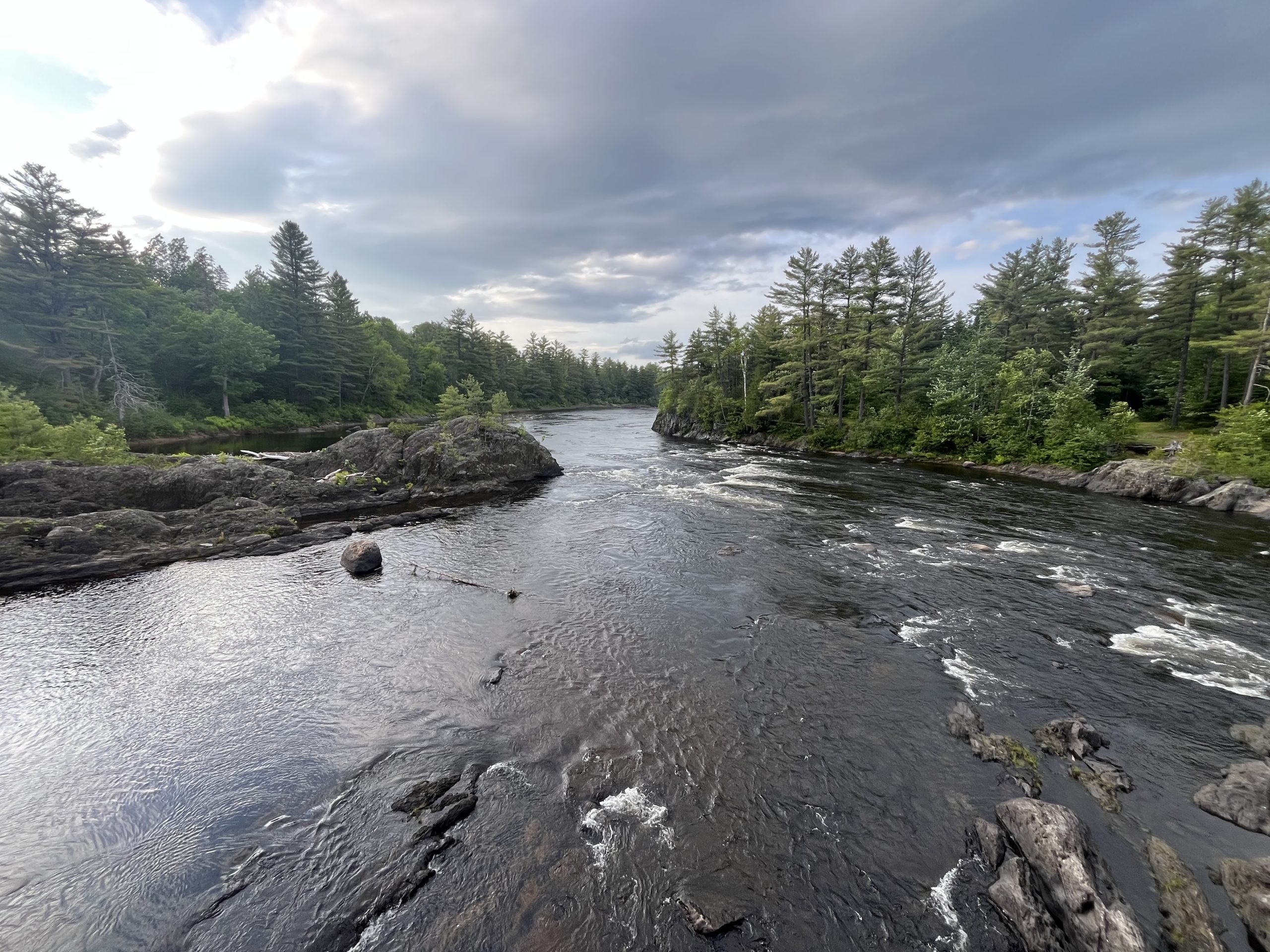
Some of the best views of the afternoon were of this river. Otherwise I was just walking along a logging road through a dense forest.
As I continued along the dirt road, I eventually went past the designated campground. Two vans were set up there for the night. And I probably could’ve joined and done the same. Though at the time it was still pretty early. And I only had another 2–3 miles to go to the day use area. Passed there I couldn’t see anything on my map which looked workable. And once again, I haven’t had service in days. So I decided to just hope for the best and push onto this area.
When I got to the day use area, I had some mixed feelings. It was right alongside a beautiful river and it was a really nice spot. There was a privy, but there weren’t any picnic tables or anything. So it didn’t necessarily seem like a super popular location. It was also off of a dirt road, which meant it would be a bit quieter. I had only seen two cars all day long. But I saw a couple of beer cans and there were some graffiti on nearby rocks. I just don’t like camping this close to a road if I can avoid it. But without knowing what laid ahead of me, it was tough to make the call.

Views only 50 feet from my tent site for the night.
I walked around the site until I found an area to pitch my tent, which wasn’t visible by traffic in either direction. Oncoming cars couldn’t see me and neither could vehicles which were crossing the bridge on the other side of the river. So at least I had that going for me. Vehicles wouldn’t be able to see me simply as they drove by. But, if someone pulled in and got out of their vehicle, then they would definitely be able to see my tent. It made me a little bit nervous, but it seems like my only option. So I got my tent set up and got inside. Fortunately, within the next two hours, it would be dark out. But it was only just after 7 PM when I arrived, so I still had a lot of time before then.
I made dinner and filtered some water. Then briefly sat down by the beach and enjoyed the views. Though, I did not want to linger too long in case a vehicle drove by. Because I don’t have a car I think it would look very strange if someone saw me and didn’t see a vehicle in the day use area. I just don’t want to attract any attention. I’m not worried about being told to leave necessarily as much as I’m worried about random men harassing me.
Eventually, I got into my tent and was situated for the night. This time around, I pulled everything inside. Usually, I don’t sleep with my backpack and shoes inside my tent. But this seemed like unique circumstances. I also made sure to have my mace and my GARMIN very handy. But unfortunately, I don’t have cell reception, which would’ve given me good peace of mind.
I wound up falling asleep pretty early and slept hard for a while. Then just before 11 PM I woke up suddenly to noises and lights. I hadn’t heard a vehicle pull into the parking lot, but someone had. And now passengers were walking along the shore and shining their lights in my tent. I heard one male voice say “is that a person over there?” Which is not what I wanted to hear.
In this moment, I made a quick decision not to say anything. I think typically guys would assume that I was also a man. I didn’t have a vehicle and I was tented randomly alongside the road. I think no part of them would’ve even considered that I was a woman alone in my tent. So I didn’t want to give them any reason to believe that. When they came closer and shined the lights at my tent, I simply turned my light on bright and shined it right back at them. That deterred them from coming any closer. I just hoped that it made them nervous and maybe they were worried that I was armed. I never wound up saying a word. Part of me considered trying to put on a male voice and yell at them to go away. But it just seemed like it might do more harm than good.
I pulled my mace out and turned my GARMIN on just in case. Then laid there quietly in my tent for an hour before they eventually left. I don’t know if they were fishing or were just sitting on the beach drinking. But they walked around a bunch and shined their lights over by my tent many more times. But they never got with it 15 feet of me again. It was a major relief when the surrounding area eventually went dark and I heard their car turn over. Then after a while, it was obvious that they had all left. I’m sure that those guys meant me no harm. Obviously I seem to have surprised them more than anything. They came out to that area and definitely weren’t expecting to see a tent. But I was just glad that I chose to remain silence and not let them know that I was a woman. Growing up my mom always used to tell me “there are people who will steal, people who won’t, and people who might under the right circumstances“. And I think that that mantra goes for a lot of things.
I was riding pretty high after that experience, but was able to calm myself down. I think it was made easier by the fact that the guys were there for so long and yet we didn’t have an additional encounter. Within the first 15 minutes of them being there, my adrenaline went down, and it became very obvious that they had no intention of bothering me. So after they left, I laid up for a little while, but was eventually able to roll back over and fall asleep for the rest of the night. I’ll just be excited to get up in the morning and continue along my route. Then tomorrow rather than stealth camping alongside the road, I’m likely going to try to stay in a room for the night.
If you enjoyed this blog and would like to support my hike by buying me a soda or a snack along the way, there is a “Tip the Author” button below! It links directly to my Venmo. Any and all support is incredibly appreciated!


